Over the past two millennia, the urban landscape of Noord-Holland evolved from sparse, marshy agrarian settlements into a dynamic metropolitan network dominated by major trading and industrial centers.
During the Roman era and early Middle Ages (0–1000 AD), the region lacked large urban centers, with small coastal and inland communities like Velsen forming the primary nuclei of human habitation.
By the 12th and 13th centuries, towns such as Haarlem, Alkmaar, and Medemblik began to consolidate population growth as trade routes expanded across the Zuiderzee and the North Sea.
Haarlem emerged early as the preeminent regional stronghold, receiving city rights in 1245 and growing into one of the most populous urban centers in the county of Holland.
Amsterdam, founded as a modest fishing village along a dammed river in the late 13th century, initiated a period of unprecedented demographic expansion.
Throughout the Dutch Golden Age in the 17th century, Amsterdam experienced an explosive population boom, rapidly becoming the largest city in Noord-Holland and a global economic hub.
Alkmaar developed into the dominant urban hub of North-West Kennemerland, drawing rural populations from surrounding polders through its thriving regional markets.
In the northern region of West-Friesland, Hoorn and Enkhuizen grew into major maritime cities during the 16th and 17th centuries, accommodating large populations of sailors, merchants, and craftsmen.
The 18th century brought economic stagnation and population decline to many coastal cities, though Amsterdam maintained its status as the demographic primate city of the province.
The 19th-century Industrial Revolution reignited rapid urbanization, particularly in the Zaanstreek region, where towns like Zaandam expanded as industrial workers settled along the Zaan River.
Den Helder grew rapidly during the 19th and 20th centuries as it was designated the primary naval base of the Netherlands, attracting military personnel and supporting industries.
In the early to mid-20th century, Hilversum expanded significantly as the garden city of the Gooi region and the broadcasting capital of the nation.
Following the Second World War, suburbanization policies led to the planned expansion of suburban nodes such as Purmerend and Amstelveen to accommodate overflow population from Amsterdam.
In 1974, the historic industrial communities along the Zaan were administratively unified into the municipality of Zaanstad, creating one of the province's largest population centers.
Haarlem consistently maintained its position as the second-largest city in Noord-Holland throughout modern history, serving as a key cultural, residential, and administrative center.
Haarlemmermeer expanded into a major demographic core following the 19th-century drainage of its lake and the subsequent growth of Amsterdam Airport Schiphol and surrounding commercial hubs.
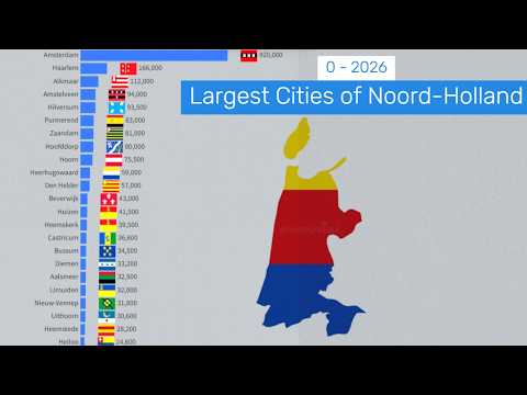
By the early 21st century, Amsterdam surpassed 800,000 residents, maintaining its position as both the largest city in the province and the capital of the Netherlands.
Modern urban consolidation has solidified Amsterdam, Haarlem, Zaanstad, Haarlemmermeer, Alkmaar, Hilversum, Amstelveen, Purmerend, Hoorn, and Den Helder as the top population centers of the province.
Demographic trends heading toward 2026 reflect high-density urban transformation, transit-oriented development, and sustained international migration within the North Wing of the Randstad.
Looking across the full historical span from 0 to 2026, the demographic center of gravity in Noord-Holland permanently shifted from scattered agrarian hamlets to a hyper-connected, world-class urban agglomeration.
urbanization, population history, noord holland, amsterdam, haarlem, alkmaar, zaanstad, hoorn, enkhuizen, den helder, hilversum, amstelveen, purmerend, haarlemmermeer, randstad, demographic evolution, city rights, golden age, industrial revolution, regional geography
#demographics #holland #amsterdam

 Log in